

Whitehorse Council Project 2024: Canopy Cover Estimation
Canopy cover is critical for urban heat reduction. Local governments strive to maximise their canopy cover to reduce the urban heat island effect since Australia is vulnerable to hot weather that impacts liveability in its urban communities.
By adding tree cover, especially in strategic locations, the urban heat island effect can be mitigated by cooling the surrounding air and surfaces.
Trees also provide shading, release water vapour via transpiration, and have a higher albedo so that they reflect sunlight better than dark surfaces such as concrete and asphalt.
Whitehorse City Council (WCC) has a strategy to increase its canopy cover to 27% by 2031 and 30% by 2050 using appropriate town planning measures. Canopy cover can be measured by analysing Aerial Imagery and/or LiDAR data acquired from commercial suppliers. Analysis techniques such as Machine and Deep Learning can be applied to identify the trees from the urban background. WCC has engaged a team of RWC researchers and interns to analyse both LiDAR and Aerial Imagery data to extract vegetation canopy cover for the Whitehorse Local Government Area.
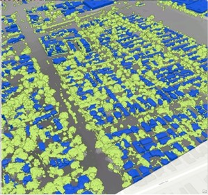
A workflow will be developed to benchmark the process of determining canopy cover using. elevation and canopy height models.. The estimated cover will be compared to the results obtained by the commercial supplier and also the State Government’s Cooling and Greening Report1.
In future stages, this methodology can be applied to analyse new datasets as they become available.