

Point Cloud Data Projects
Point Cloud is a recent format to complement the traditional raster and vector formats that are used for geospatial data. Point clouds are simply sets of 3D (x, y, z) points in some spatial reference frame. Colour and intensity data may also be included for additional detail. These are generally acquired from 3D scanners that project light at objects and interpret the scattered rays.
Point clouds have many applications for visualization, rendering and animation. Engineering and medical fields including medical imaging, 3D printing, manufacturing, architecture and construction, 3D gaming, and augmented (AR) and virtual reality (VR) applications make extensive use of 3D point clouds.
Open3D is a Python library that can be used to analyse and visualize point cloud datasets.
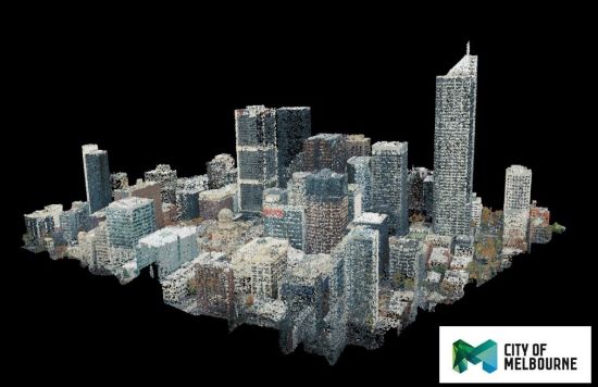
The figure shows the City of Melbourne (COM) visualized using point cloud data with Open3D in LAS (LASer) format collected using LIDAR scans freely available from the COM website. One disadvantage of using point clouds is that voluminous data files can be generated by the scanning process. For example, the COM point cloud dataset consists of 215 LIDAR files totalling over 4GB.
Ryan Watson Consulting is investigating the use of point cloud data for geospatial applications including 3D topology influences at road accident hotspots.